
Image
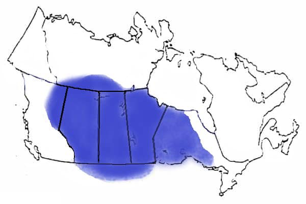
Image Caption
Summary
Windspeaker.com Contributor
A genealogical presentation by a Metis Nation-Saskatchewan (MN-S) employee that included a map of Metis presence in Canada has further strained relations between four of the five Metis Nation groups in the country.
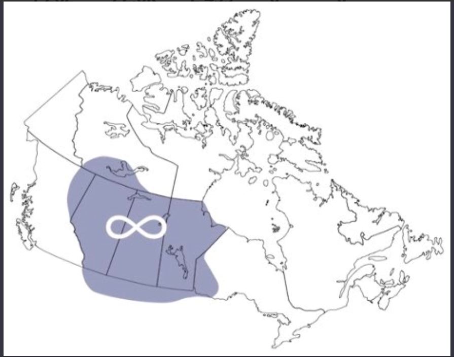
On Feb. 13, Will Goodon, minister for housing for the Manitoba Metis Federation, tweeted the map, calling it a “stunning reveal” and “part of a secret agenda” of MN-S, the Metis Nation of Alberta (MNA) and the Metis Nation of Ontario (MNO) that “is now open for everyone to see.”
However, a spokesperson for the MN-S says the map was taken from a humanities website for the presentation.
In a statement to Windspeaker.com on Feb. 18 a spokesperson for the MN-S said, “It is not an official map. It is disheartening that so much misinformation could be brought to this circumstance.”
According to a French-language website, the map titled Metis in the Northwest shows “many of the new Metis colonies that settled in the northwest followed the Red River colony model buffalo hunting. In the early 1870s, the bison population declined greatly due to too much hunting.”
What signifies the Metis homeland has been a point of contention for the four Metis Nation governments and the Metis National Council (MNC). In November 2018, the Métis National Council General Assembly adopted a report which included a map of the Metis homeland.
While the provinces of Alberta, Saskatchewan, and Manitoba are fully included as part of the Metis homeland, only smaller portions of Ontario, British Columbia and the Northwest Territories are marked within those boundaries.
For the MNO, that 2018 map is problematic as it has accepted many more regions and people as both historical Metis communities and Metis citizens. That, in turn, resulted in a resolution November 2018 by the Métis National Council General Assembly to put the MNO on probation for a year to align its citizenship registry with the national definition of Metis, which had been adopted in 2002. In January, the MNO received a letter from MNC President Clement Chartier saying the MNO had been suspended.
It’s a suspension that the presidents of MNO, MNA and MN-S say can’t be made by Chartier alone, but needs to be made by the MNC General Assembly.
The MNO received the suspension letter just after it wrapped up a three-day meeting hosted by MNA, with MN-S in attendance as well. The three governments had met to determine ways they could work together to advance the Métis Government Recognition and Self-Government Agreements each signed with the federal government in June 2019.
It’s what Goodon calls “backroom deals” that has him believing the map that was included as part of the MN-S presentation was no mistake. That map more closely aligns with the Metis homeland map that was used when the MNC was formed in 1983 and includes the greater area that MNO says is part of the Metis homeland.
Goodon won’t say how he got a copy of the map used last week.
“My understanding is what’s happening in Saskatchewan right now is that when people get out of line, there’s punishment that happens," he alleges, "and I would not want to be responsible for someone’s career being hurt.”
The MN-S would not name the employee who put together the presentation or whether the map was part of an in-house genealogical presentation or a public presentation.
“It’s been absolutely verified (the map has) been sent to the registry staff throughout the province and they were told to use this as the new format for determining Metis citizenship,” said Goodon.
MNA President Audrey Poitras says she only became aware of the map when the controversy broke.
“I have no idea where that (map) came from or anything else. What I do know from the time I’ve been president and even before that since 1983 when Metis National Council was formed there was a map because we, as Metis National Council wanted to be at the Canada tables and there needed to be a map of the homeland,” said Poitras.
Poitras included this 1983 map in a statement she posted on MNA’s website Feb. 12 for members emphasizing that this was the map MNA accepted and that the MNA alone represented Metis Nation citizens.
As far as Poitras is concerned, the November 2018 Metis homeland map is not official.
“This map, no map, has ever come back for us to approve as Metis Nation citizens in all of those five provinces,” she said. “Everything that changes our governing structure has to go through a process.”
However, as far as Goodon is concerned, the same could be said for the 1983 Metis homeland map.
“(The) 1983 homeland map … was never approved by the general assembly. It was just a rough drawing at that time and the only map that’s been approved by the Metis Nation was the one approved in 2018,” he said.